Engineers will develop a new type of signal processing that can lead to deeper and more precise mapping of groundwater resources from the air.
Using a helicopter-borne antenna system, scientists can identify underground water resources, even in areas where the subsurface is very complex.
In the coming years, researchers at Aarhus University will contribute to developing the world-renowned SkyTEM technology for mapping subsurface water resources.
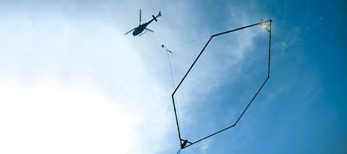
SkyTEM was developed at Aarhus University in the 1990s and was one of the first technologies to enable airborne groundwater measurements. The technology consists of a large frame with highly advanced equipment that can be attached to the underside of a helicopter. This makes it possible to cover large areas in the search for aquifers or geological formations that contain or conduct groundwater.
Seeing through the subsurface
A coil is placed in the frame, and it generates a strong magnetic field that penetrates into the ground. The magnetic field disappears when the power is switched off, and this change induces eddy currents in the soil. The eddy currents give rise to a secondary magnetic field that can be measured by advanced equipment, and the rate at which it decreases provides information about the conductivity of the material in the subsurface at the specific measurement point.
Researchers currently use the technology to identify the material in the layers in the subsurface, which is enabled by more sophisticated computer modelling methods.
“When you’re familiar with the correlation between geological structures and conductivity, you can use computer modelling of measurement data to very precisely identify subsurface water resources,” says Assistant Professor Jakob Juul Larsen who works with signal processing.
Mathematical models provide new details
According to Assistant Professor Larsen, the challenge facing the engineers with SkyTEM is to identify better ways to process the signals from the magnetic field and to find mathematical models that can enable them to record more details in the eddy currents when the signal drops.
“We’d like to develop the technology and be better at characterising the ground’s response to the magnetic field we send from the air,” he says.
The researchers hope to be able to reduce noise in the signal within three years and carry out deeper and more precise mapping of groundwater resources from the air.
Data from magnetic fieldsWith the aid of a helicopter, it is possible to fly a frame with cables that act as a coil at a height of 15–30 metres above the ground. From here a high-strength current in the coil forms a primary magnetic field. |

