We are currently offering Master's, Bachelor's, and R&D engineering projects with wireless communications, networking and data analytics.
This project investigates whether a Virtual Machine (VM) can serve as a persistent network counterpart to a physical object moving through a supply chain. As the object passes successive RFID readers, the VM migrates to the nearest host, maintaining a stable IPv6 address cryptographically bound to the object's EPC identifier. At each checkpoint the VM performs local computation and writes a signed record back onto the physical tag, creating a physically embodied audit trail that remains intact independent of network continuity. The project combines Xen live migration, Software Defined Networking, and Cryptographically Generated Addresses (CGA) to realise and evaluate this concept in a testbed environment.
Keywords: Internet of Things, RFID, IP networking
Contact: rhj@ece.au.dk
IoT promises a world where physical objects are continuously reachable and addressable over the Internet. In supply chain management, RFID technology has become a cornerstone for tracking goods as they move between locations. However, a fundamental gap exists between the physical movement of tagged objects and their persistent network presence. When a passive RFID tag moves between readers, any associated network state is lost, making it impossible to maintain a continuous, addressable identity for the object.
This project proposes that a VM acting as the network counterpart of a physical object should migrate along with the object as it moves through the supply chain. A key motivation is that latency-critical local decisions can be made by the VM at the point of reader encounter, without incurring the round-trip delay of consulting a central server. Crucially, when the VM computes a decision or issues a compliance certificate at a checkpoint, it can instruct the local reader to write that result back onto the physical tag. The tag thereby becomes a physically embodied audit trail, carrying verified state from each checkpoint independently of network infrastructure. The VM and the tag act as complementary state carriers: the VM provides rich networked computation, while the tag provides a physically resilient record that survives even if network continuity is interrupted.
Passive RFID tags cannot host a network stack. However, as established in prior work, a reader can assign an IPv6 address to a VM acting as the tag's network counterpart, constructing the address from the tag's EPC using CGAs. The challenge arises when the object moves to a new reader: the network prefix changes, the old address becomes unreachable, and network continuity is lost.
This project addresses the following core research question: Can a live VM migration, triggered by and synchronised with the physical movement of an RFID-tagged object between readers, maintain continuous network reachability and preserve computational state across subnet boundaries, while using write-to-tag operations to maintain a physically embodied audit trail on the tag itself?
Three interrelated problems must be solved. How can the VM's network identity be cryptographically bound to the tag's EPC such that the identity remains stable as the VM migrates? How can reader events trigger VM migration in a timely manner, given that a passive tag can only report data at the moment of a reader encounter? And how can the underlying network, using SDN techniques such as OpenFlow, ensure that the VM's IP address remains routable after migration to a host on a different subnet?
The project will proceed in three phases, building on preliminary work already undertaken in constructing IPv6 addresses from EPC identifiers using CGA techniques.
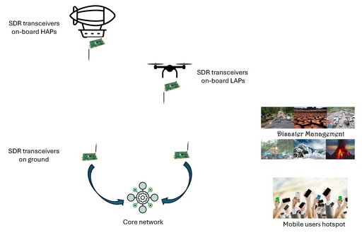
The main objective of the project is to create a mobile and centralized communication network that can be used in different applications. The current 4G LTE, and 5G is comprised of mainly fixed remote radio heads (RRHs) to collect and send information to mobile users through transceivers. However, there are many applications and instances when we require mobile RRHs. For example, providing coverage to a sudden mobile users hotspot, and disaster management.
The objective of the project is to create a mobile RRH on-board unmanned high-altitude platforms (HAPs) and low altitude platforms (LAPs). The mobile RRH on-board unmanned HAPs and LAPs will be able to cognitively maneuver to optimum locations using reinforcement learning. The additional height and mobility will be the key players for optimum coverage on demand. Multiple RRHs will be connected to the base band units that are connected to the centralized core network as shown in the figure below. SDRs will be used as transceivers on the HAPs/LAPs and on the ground.
It is expected that student/s will learn the basics of real time communications using SDRs and possible challenges in the implementation and optimization. Another learning outcome is cognitive manoeuvring of unmanned aerial vehicles using reinforcement learning keeping in view the optimum coverage.
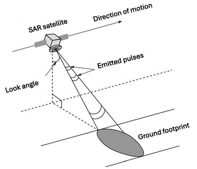
There are many locations in Denmark that are covered by cloud mostly throughout the year. Therefore, visible and infrared sensing cannot provide accurate condition of the earth surface. Using synthetic aperture that can penetrate through clouds can provide an accurate picture of earth surface. Accurate ground conditions can help many sectors including agriculture and livestock.
The objective of the project is to process the synthetic aperture radars (SAR) data of earth surface obtained from a satellite. The data is processed using sparse and SAR signal processing algorithms. Deep neural networks is used to improve classification and forecasting.
Sparse synthetic aperture radar data processing obtained through satellites from different earth locations. The data is processed using sparse signal processing and artificial intelligence.
Learning outcomes include understand the sparse signal processing for SAR, understanding the impairments due to the satellite channel, obtain a high resolution image of the earth surface, and classification and forecasting using deep neural networks.
The main objective of the project is to create a mobile and centralized communication network that can be used in different applications. The current 4G LTE, and 5G is comprised of mainly fixed remote radio heads (RRHs) to collect and send information to mobile users through transceivers. However, there are many applications and instances when we require mobile RRHs. For example, providing coverage to a sudden mobile users hotspot, and disaster management.
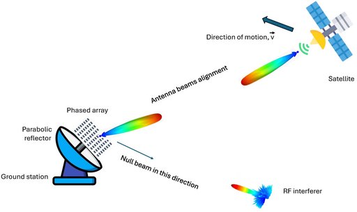
The low earth orbit (LEO) satellites move at a very velocity (7.8 km/s) and the link distance is in hundreds of kilometers. Therefore, the RF link between the satellite and ground station should be aligned. The objective of the project is to create a high gain antenna beam that can be steered in space to remain aligned with the fast-moving low-earth orbit. In addition, cognitive beamforming (through reinforcement learning) and steering can be used to supress the RF interferers.
The learning outcomes include optimum phased array antenna design with associated beam forming and steering that can be controlled cognitively through reinforcement learning. Moreover, the student/s will learn how alignment affects satellite communications. In particular, a good antenna beam alignment and interference suppression can help to achieve high throughput.
The students are expected to work on HFSS software, and PCB antenna manufacturing and other RF equipment for beam forming and steering.
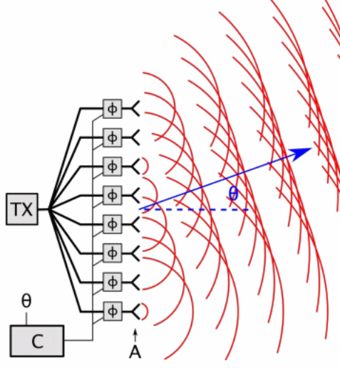
| Beam Steering and Beamforming Algorithms for Nanosatellite Communications
The goal of this project is to develop beam steering and beamforming algorithms for nanosatellites. A depiction of beam steering is shown in the figure, where by controlling the phases of the feeding signals to the antennas, the direction of the whole radiation pattern can be electronically controlled. This is achieved by providing an input steering angle to the controller C in the diagram. Beamforming is similar, but instead, also the form of the pattern can be designed as well. The work will focus on the beam steering and beamforming algorithms obtained from an input reference angle from the satellite attitude determination and control system (ADCS) to a desired target angle. Reference signals to digital phase shifters will be considered. The algorithms will be developed in high-level language for design and analysis, where implementation will be carried in a low end platform such as the Arduino or the Raspberry Pi. The student will have the opportunity to work hands-on with our NAN lab facilities, nanosatellite equipment and collaborate on current research in satellite projects. PrerequisitesProgramming in a high-level (e.g. Python) or/and low-level (C/C++), Linux, embedded programming. ContactsRune Hylsberg Jacobsen (rhj@eng.au.dk)
(image sources: Wikipedia (top), Adaptive beam steering (bottom)) |

 There is a current need for new techniques to improve the communication link between satellites and between satellites and ground stations, without changing the pointing of the satellites.